PRECISE INDOOR POSITIONING AND TRACKING FOR DRONES, UAV, UAS
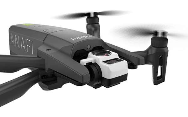
Dragonfly computer vision technology lets you get real-time 3D location of a flying drone, using an on-board camera.
Indoor tracking and positioning for drones is a challenging task, where GPS / GNSS cannot be used. When operating indoors and in GPS-denied environments, alternative systems must be considered.
Dragonfly can leverage the on-board hardware and work entirely offline. It can work inside known and unknown environments and does not require the deployment of specific hardware in your venue. No receivers, no tags, no antennas, no nodes. Nothing has to be deployed through the environment. As a result, Dragonfly is a super flexible technology for indoor tracking, navigation and positioning.
DISCOVER
How does Dragonfly for drones positioning and tracking work?
Dragonfly is an indoor location technology that provides very precise location. Dragonfly calculates the location using just an on-board camera. No sensor fusion, no MEMS, no hardware to be deployed on site, no QR codes. Dragonfly needs to get a 640 x 480 pixels video stream from the drone. The camera can be monocular (ideally wide angle) or stereoscopic, and it can point towards any direction (preferably towards the ceiling). The existing camera of the drone can be used, as long as the video stream can be consumed by the Dragonfly software. Take a look at this page for more information about the supported video streams.
WHY DRAGONFLY CAN BE THE SOLUTION TO YOUR LOCATION PROBLEMS?
Dragonfly is an exceptionally flexible technology for precise indoor positioning and location of drones and any other moving vehicle.
Cost effective alternative to Lidar and UWB
Cost effective alternative to Lidar and UWB
No hardware in your venue
No receivers, no tags, no antennas, no nodes. Nothing has to be deployed through the venue. As a consequence, Dragonfly is a super flexible technology for indoor tracking, navigation and positioning.
Easy setup
No tech skills required, no difficult instructions. As a result, Dragonfly can be installed and configured in less than 1 hour. In addition to this, if you need support you can rely on: our award-winning Technical Support team and an outstanding Technical Support website
One on-board camera
Dragonfly does not need specific hardware, IMU, sensor fusion, LiDAR, magnetic stripes, QR codes... The existing on-board camera can be leveraged.
Completely offline
No internet connection needed. As a result, Dragonfly can run completely offline, on board of drones or on an on-premise server.
It scales with you
Dragonfly is a scalable technology: there are no minimum or maximum number of drones that can use the technology at the same time.
For all these reasons, our customers consider Dragonfly to be the solution to their indoor location problems!
FEATURES
3D positions (X, Y, Z) and orientation (yaw, pitch, roll) of your drones
Positions via real-time API or CSV files
Average accuracy of 10 cm!
No internet connection required
Dragonfly is an accurate indoor location system based on computer vision.
The location is computed in real time using just an on board camera and a computing unit on board of the device to be tracked, thanks to our computer vision algorithm. Computer vision, odometry and artificial intelligence are used to create an accurate indoor location system, in order to deliver a precise location for multiple applications. It is an excellent solution for the precise indoor tracking of drones (in the 3D space).
API, DRAGONFLY CLOUD DASHBOARD and ROS
- Outstanding API and CSV files can be used to integrate the location data into external application, navigation systems, remote tracking software, and more.
- Dragonfly allows to monitor the real-time location of the drones from the Dragonfly Cloud Dashboard.
- ROS nodes can be developed by Onit’s team to ease the integration with ROS.
Are you ready to get started?
DRAGONFLY CLOUD DASHBOARD
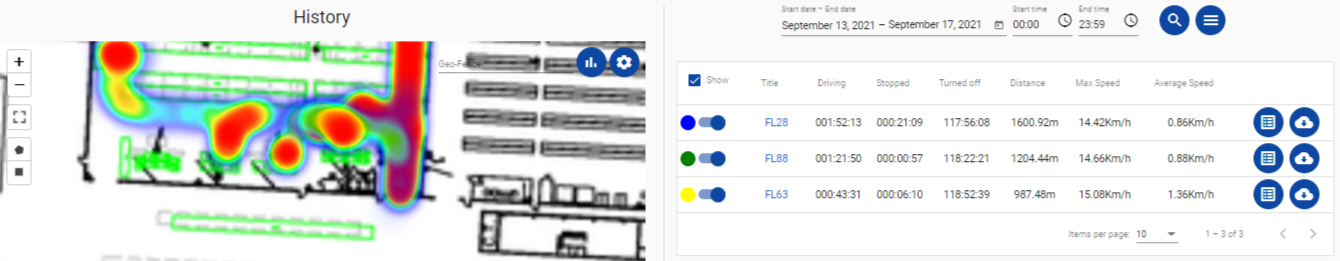
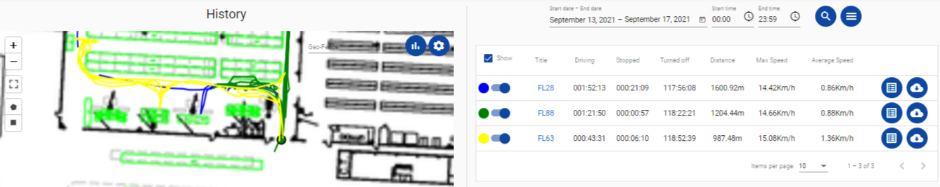

Track the real time and historical locations of your devices
Add a floor plan to see the location on a real blueprint
Visualize your data as: spaghetti lines, time lines, height lines and heatmaps!
Search data for 1 day or across multiple days
Search for data related to a specific area (geo-fence)
Get metrics like: maximum and average speed, travelled distance, drive time, stop time etc...
Export your data as plots and CSV files
ARCHITECTURES
Dragonfly can work directly on board of the drone or a local on-premise server. Let us help you pick the best option.
On board processing
One computing unit for each device to be tracked
No Internet connection
Optional WLAN connection
On premise processing
One (or multiple) central server(s) per-location
No Internet connection
Mandatory reliable WLAN connection