DRAGONFLY
Precise 2D and 3D indoor location, tracking and navigation of
forklifts, AGVs, AMRs, robots, drones
based on computer vision vSLAM algorithms
Dragonfly is Onit’s cutting-edge computer vision indoor localization technology based on visual SLAM that provides accurate indoor position and orientation to forklifts, automated guided vehicles (AGV), autonomous mobile robots robots (AMR), robots, drones and any other moving vehicle and asset.
Dragonfly enables RTLS solutions for analytics, productivity and safety in GPS-denied environments like warehouses, production plants, factories etc.. in any industry vertical.
Dragonfly delivers the X-Y-Z coordinates and 3D orientation of any moving device with centimeter-level accuracy, by analyzing in real-time the video stream coming from a standard wide-angle camera connected to a small computing unit.
Dragonfly represents the state-of-the-art for indoor localization technologies at locations where GPS/GNSS cannot be used and it is much more competitive compared to other indoor localization technologies based on LiDAR, Ultra Wide Bandwidth, Wi-Fi, Bluetooth RSS.

HOW DOES IT WORK?
The principle of operation is very simple
Step 1 - One-time mapping
During the system setup phase the wide-angle camera sends the video feed of its surroundings to the computing unit. The computing unit takes care of extracting the features of the environment, in each of the frames, and creating a 3D map of the environment (which is geo-referenced using a DWG file of the area).
Step 2 - Localization
During its usage in production the wide-angle camera sends the real-time video feed of its surroundings to the computing unit. The computing unit extracts the features of the environment in each of the frames and compare them with those within the previously created 3D map of the environment.
This process allows Dragonfly to calculate at more than 30 Hz the X-Y-Z position and orientation in the 3D space of the camera (and thus of the mobile asset on which it is mounted).
Accurate indoor localization with Computer Vision
Forklifts tracking indoor at Modani Furniture warehouse United States
Indoor Localization technology inside a warehouse with Computer Vision
Real-time indoor localization of multiple autonomous robots in a retail environment
FEATURES
Centimeter-level accurate X-Y-Z position
3D spatial orientation
Ready-to-use analytics (spaghetti lines, time lines, heatmaps)
Integration via real-time API and CSV files
No internet connection required
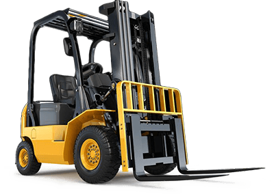
Dragonfly is an accurate indoor location system based on computer vision. The location is computed in real time using just an on board camera and a computing unit on board of the device to be tracked, thanks to our computer vision algorithm. Computer vision, odometry and artificial intelligence are used to create an accurate system, in order to deliver a precise location for multiple applications. It is an excellent solution for the precise indoor tracking of forklifts, AGV, AMR, robots and drones (in the 3D space).
WHY DRAGONFLY
Dragonfly is an exceptionally flexible technology for precise positioning and location indoor of forklifts fleets, AGV, AMR, robots, drones and any other moving vehicle
Non-invasive architecture
Dragonfly is way more competitive than LiDAR, UWB, radio signal based technologies for which an ad-hoc infrastructure must be designed, setup, calibrated and maintained for each specific venue.
No receivers, no RFID tags, no antennas, no nodes, no magnetic stripes. Nothing has to be deployed through the venue. You need just a camera and a computing unit onboard your mobile vehicles.
Seamless setup
No tech skills required, no difficult instructions, no need for error-prone and time-consuming calibrations of ad-hoc UWB infrastructure. Dragonfly can be installed and configured in less few hours and if you need support you can rely on our award-winning Technical Support team and our outstanding Technical Support website
Easy maintenance
vSLAM technology is much more robust to environmental changes as opposed to LiDAR, which struggles considerably to maintain accuracy in environments in which obstacles change over time. Dragonfly cameras are easier to calibrate and are more robust to changes in the environment.
Robust and scalable
Dragonfly distributed architecture makes the solution reliable by eliminating mandatory server that led to SPOF (single points of failures). This also means that Dragonfly can grow following the size and growth of your fleet of moving vehicles.
No internet connection
Dragonfly can work completely offline on a computing unit on board of forklift, AVG, AMR, drones, robots or on an on-premise server.
High ROI
Dragonfly allows you to optimize your operations, increasing the productivity and effectiveness of the tracked devices. In addition to this its competitive price, makes the ROI higher than any other technology currently on the market.
For all these reasons, our customers worldwide consider Dragonfly to be the solution to their indoor location needs
ARCHITECTURES
Dragonfly can work directly on board of the device, or on a local on-premise server
On board processing
One computing unit for each device to be tracked
No Internet connection
Optional WLAN connection
On premise processing
One (or multiple) central server(s) per-location
No Internet connection
Mandatory reliable WLAN connection


USE CASES AND APPLICATION ENABLED
The locations provided by Dragonfly can be integrated into several applications
Enhance the operations
Enhance the operations thanks to a real-time visibility of the actual utilization and path of your mobile vehicles (like forklifts) to avoid under/over utilization and maximize the performance of the fleet.
Maximize safety
Know in real-time the location of each moving asset to prevent accidents between human-guided mobile vehicles (such as forklifts) inside warehouses and production facilities enabling thus V2V (vehicle to vehicle) and V2P (vehicles to pedestrians) applications for collision-avoidance.
Improve logistics productivity
Speed up the productivity by tracking the location of each moving asset to indirectly know the position of each handling unit on the ground, racks and shelves. Minimize low-value activities in logistics like the manual, long and error prone search of handling unit inside warehouses thanks to an automated inventory management that will benefit your warehouse management system (WMS).
Streamline maintenance
Predict maintenance operations of mobile vehicles (like lift trucks) by analyzing their usage over time to avoid sudden breakage and inactivity of valuable assets.
Download the case studies and learn how Dragonfly is improving the operations of our customers!
DISCOVER
Two different architectures
Dragonfly engine can run locally on board of the unit to be tracked or on a local server, thus giving you all the flexibility you need.
Real-time 2D and 3D location
Dragonfly is a 3D location system and the location is provided as 6-DOF:
- X, Y, Z metric distances from an origin;
- WGS-84 latitude and longitude coordinates.
- the orientation as yaw, pitch, roll angles;
- the altitude off the floor (in meters).
Highest accuracy
Dragonfly can provide centimeter level location accuracy. This can be used for precise navigation in 3D, and is a perfect system for tracking of forklifts, drones, robots, AGV, AMR and any other moving asset.
COMPONENTS
Wide-angle camera
An on board fish eye monocular camera and a computing unit are the only required hardware to use Dragonfly. No external sensors, hardware or antennas have to be installed in your venue.
Computing unit
Dragonfly can run on a local server or on board of the device that needs to be tracked. As a result, you can pick the best architecture for your needs.
Dragonfly Web User Interface
A professional and user friendly GUI is provided to configure, monitor Dragonfly and manage the maps of your venue.
Dragonfly Cloud Dashboard
The outstanding Dragonfly Cloud dashboard is provided to track remotely the units equipped with Dragonfly in real time, access historical analytics, metrics and KPIs and export all the plots and data sheets that you need to improve your operations.
DRAGONFLY CLOUD DASHBOARD
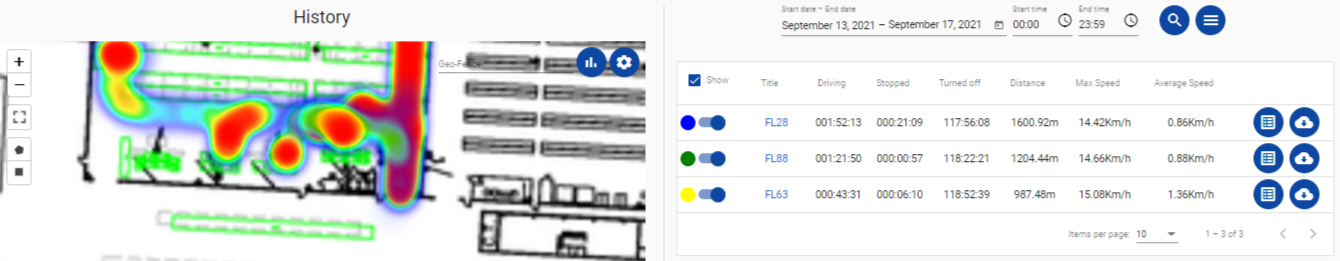
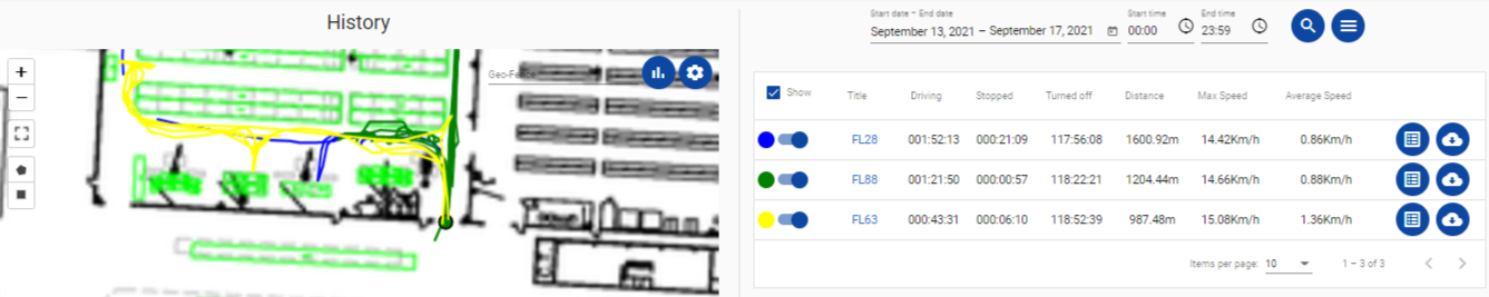

Track real time and historical locations of your devices
Add a floor plan to see the location on a real blueprint
Visualize your data as: spaghetti lines, time lines, height lines and heatmaps!
Search data for 1 day or across multiple days
Search for data related to a specific area (geo-fence)
Get metrics like: maximum and average speed, travelled distance, drive time, stop time etc..
Export your data as plots and CSV files
INTEGRATION
REST API
Integration has never been easier. Dragonfly gives access to an application programming interface (API) that can be used to manage each Dragonfly instance running on board of the device that needs to be tracked, or on a local server. The API is extensively documented inside the Dragonfly Support site.
ROS integrations
Dragonfly is a visual positioning system for ROS (Robot Operating System) and allows to integrate its accurate location into robots and drones. For this reason, we are open to develop ROS nodes upon request, to have a direct integration on-board. Contact us for more details
FAQ
What are the hardware specifications required to use Dragonfly?
Dragonfly works on x64 architectures (and runs natively on Ubuntu 18/20/22 and Windows 10/11), and ARM64 architectures (like NVIDIA Jetson and Raspberry Pi devices). To achieve the maximum performance, it is recommended a computing unit equipped with a CPU with 4 physical cores @1.8 GHz and 8 GB of RAM. The camera must have a wide-angle lens that allows viewing of a wide area of the environment.
Can Dragonfly be used in any venue?
Yes. If in your environment the features that Dragonfly sees are lacking or are not distinctive enough, then fiducial markers should be added: they are inexpensive and Dragonfly specialists will advise where to place them. So, please feel free to contact us to analyze your project and requirements with one of our specialists.
Is Dragonfly open source?
No, Dragonfly is a commercial technology that can be integrated into custom applications.
WHAT IS THE ACCURACY OF DRAGONFLY?
Dragonfly can provide a centimeter-level accuracy. Read more about accuracy.
Should I create 3D maps for each moving asset?
No. The mapping should be done with only one of your moving assets, then this map is shared with the rest of the fleet.
Can I use Dragonfly to create 3D maps and models?
No, Dragonfly is meant to provide precise indoor location to forklifts, AGV, AMR, drones, robots and any other moving devices. The 3D map created with Dragonfly is not meant to be human intelligible (nor readable by any other software), because Dragonfly is not designed to deliver end-user 3D maps, but rather to provide the precise location of moving devices through space.
CAN I USE DRAGONFLY TO INCREASE THE SAFETY OF MY WAREHOUSE?
Yes, the positions returned by Dragonfly can be integrated into safety solutions and used, for example, to notify forklifts drivers of dangerous situations like vehicle to vehicle or vehicle to pedestrian collisions. Click here and contact us to know more!
I HAVE ALREADY A CAMERA ON BOARD OF the MOVING ASSETS TO BE TRACKED, CAN I USE IT?
Yes, Dragonfly leverages on any model of wide angles camera. So, if your moving device has already a fisheye camera on it, then you can use that camera.
I STILL HAVE QUESTIONS, CAN I SPEAK WITH A SPECIALIST?
Sure. Our team will be glad to help you. Therefore, click here to contact us and speak with a specialist.
CAN DRAGONFLY BE USED TO PERFORM INDOOR TRACKING OF DRONES?
Yes, Drone 3D positioning is possible with our indoor location system. Thus, drones can be used for inspections and maintenance tasks requiring a 3D accurate location.
LET'S TALK ABOUT YOUR PROJECT
Dragonfly is a flexible technology that can be adapted to multiple projects.
We understand that every project is unique and for this reason, you can connect with our team and explain your use case.
Contact us to today! We will be glad to analyze the best architecture for your needs.